


Please wait...
About This Project

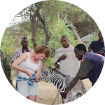
Grevy’s zebra are one of Africa’s most threatened large mammals. My project focuses on the largest extant Grevy's populations in Kenya, where animals face increasing environmental stress. The project goals are to understand how genetic diversity and environmental stress combine to affect disease risk. Results will inform efforts of Kenyan wildlife officials to mitigate the risk of disease, which they have identified as a major threat to the species' survival.

Browse Other Projects on Experiment
Related Projects
How can a cheap scanner reveal hidden signals in living soil?
Soil looks like one brown background, but water, minerals, organic matter, roots, fungi, bacteria, and decaying...
Can biome logs transform biomass from a problem to soil-ution?
As catastrophic megafires and flooding intensify across the western United States, fungi and other microbes...
Tiny worlds in desert moss: Microbes and microfauna in biological soil crusts
Desert mosses live closely with lichens and other microorganisms, together performing vital ecosystem services...