Sherman Horn III

Sherman Horn III

Oct 17, 2016

Group 6 Copy 198
1

Seeing Beneath the Canopy: LiDAR at El Pilar

High-resolution LiDAR maps are the foundation of this project, and we'd like to provide a few maps to illustrate how we use LiDAR imagery and the power of this technique. For more information on how LiDAR works, head over to the wiki page here. We examine LiDAR maps for signs of ancient structures before formulating our survey strategies for different areas. Take a look at the two examples below to see how LiDAR reveals monumental structures in areas shrouded in dense rainforest.

(North is Up)

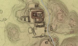
The picture above shows the largest group of monumental structures at El Pilar. It contains a LiDAR image - a section of the much larger survey - that is overlaid by architectural plan drawings from previous excavations and survey. Most of this ancient "downtown" area remains covered in jungle, although some structures and plazas have been cleared of underbrush for public access. The white line running roughly north-south is a modern road that cuts through this part of the site. You can see that the LiDAR image clearly picks up large structures, which have heavily darkened slopes and regular outlines, as well as natural hills and uplands. You can also see smaller structures, outlined in thin red lines when confirmed by survey, along with large round aguadas (reservoirs), irregular-shaped quarries, and hillslope terraces. A considerable amount of mapping was completed in this area before the LiDAR data became available, but a number of new small features were discovered after the images were examined. And just over 500 meters to the east of this scene, something truly large and unexpected was spotted.

(North is Up)

What you see above has been tentatively dubbed the "Citadel" because of its resemblance to hilltop fortifications from other areas of the world. Despite being only about half a kilometer from the thoroughly investigated monumental core, the Citadel remained unknown to us until the LiDAR images were examined. The hillside was cut into two concentric rings - drawn as black lines - which encircled a flattened top where several temple platforms were built. The largest of these structures were unfortunately damaged by looters in modern times, but analysis of pottery from the looters' trenches suggests they were built during the Late Preclassic (300 B.C. - A.D. 250), which makes the Citadel an early example of truly massive construction. Future fieldwork may help clarify if the Citadel was actually a fortification or if it served some other function, but we may never have been able to ask that question without data from the LiDAR survey. Now that we have demonstrated the power of LiDAR to pick out large structures through heavy forest cover, and we can begin to look at the big picture and discuss our research design. In the next Lab Note, we will examine the entire LiDAR survey image and point out different areas of interest, including the low-lying swampy areas where the "invisible" structures were built.


1 comment

Join the conversation!Sign In
  • Jennifer Emery
    Jennifer EmeryBacker
    How do you suppose the looters found the structures.....
    Oct 18, 2016
  • Sherman Horn III
    Sherman Horn IIIResearcher
    Looting is a huge problem in the Maya area, and there are several different ways potential looters can discover structures. Modern-day people have been living around El Pilar for some time, and it's possible that some people happened across the monumental structures while hunting in the forest or simply exploring. They could also have been noticed by chicleros, who harvested the sap of the chicozapote tree for making gum (think Chiclets), loggers, or others who made their living extracting resources from the forest. That's not to say that any of those groups are responsible for the looting - word spreads quickly about such discoveries - but to note that there were ample opportunities for people to explore, and illegally loot, the site before it was protected.
    Oct 19, 2016

About This Project

Aerial LiDAR surveys have been popular tools for mapping ancient Maya settlements through the dense rainforest canopy. LiDAR mapping at El Pilar revealed several previously unknown large structures, but many smaller structures in low, swampy areas were invisible to this technique. This project will develop a program of field-checking LiDAR anomalies to clarify the patterns of small structures in seasonal swamps, where settlement models predict people would not live.

Blast off!

Browse Other Projects on Experiment

Related Projects

A sociotechnical toolkit for coral conservation and regeneration

This project aims to develop a sociotechnical toolkit for deploying meaningful biotechnologies in coral...

Through the eyes of the afflicted: unraveling the Fentanyl crisis

This project explores the fentanyl epidemic by gathering perspectives from those affected—people with addiction...

Big data and the law: should we graph the entire justice system?

Justice systems can be represented as a graph: a network of nodes linked by different kinds of relationships...

Backer Badge Funded

A social science project funded by 77 people

Add a comment