Hugh Thomas

Hugh Thomas

Jun 07, 2017

Group 6 Copy 203
1

All in a day's work

It’s just jumped past the 3 week mark here on Andros and we have a lot of amazing finds under our belt. But it isn’t as simple as just strapping a thermal camera onto a drone and flying. We can separate the areas we photograph into two zones, Zagora and the outer fields.

Zagora:

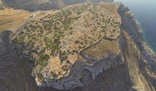
At the end of last year, I sat down with the directors of the Zagora Archaeological Project and asked them which areas they are most interested in digitally surveying. We determine a series of areas- shown in this image.

Areas we applied to clean the site. Please note: This permit does not allow us to touch archaeological remains or pick up anything. As such, we always leave a 1m buffer zone around anything old.

These boxes indicate areas where we asked the Greek ministry to allow us to clear the vegetation. The reason we clear vegetation is so that the heat from any subsurface remains can easily detected, rather than being obscured by grass. Clearing takes a lot of work. We have previously used a whipper-snipper (Weed-whacker for our US followers), but last week, on a particularly hot day, it stopped working. We were being swamped by plagues of flying ants and upon opening up the whipper-snipper, there were dead bugs everywhere. I have a feeling that they have been sucked into the engine and have caused it to die. So now, we must clear the old fashioned way- using rakes and other tools to remove vegetation (See below).

Outside fields:

For any fields beyond Zagora, we are allowed to photograph them but we are not allowed to touch anything. These fields belong to the locals and some are still used for crops or to have goats/sheep.

So we have to be respectful of these people’s property- by making sure we don’t damage anything, shutting all the gates etc. Although these fields are covered in grass, we hope something can peek through it.

Once we are ready to shoot one of these fields, we have to get it ready. We lay several large cardboard crosses throughout the area, which act as ground control points. These are shot in with a fancy GPS system that has an accuracy of around 1-3cm. From there, we then fly my new Phantom 4 Pro drone over the area. By taking normal photographs, we can then compare those to the thermal images. Basically, they act as a control.

Before and after clearing

Thermal photography works best after sunset, or before sunrise, when the ground is starting to cool off from the heat of the day. As such, we wait for the sun to set, which is often pretty nice.

Watching the sunset with Zagora in the background

Head torches get popped on and then we fly my other drone, a Phantom 2, which has the FLIR thermal camera attached to it, the camera which you helped purchase!

At 9:30pm, we walk off site, which is a 2km walk, up about 30 stories in height, with only head torches guiding our way. We quickly race down to the local gyros shop for dinner, because no one wants to cook at 10:30pm. We normally get home at around 11pm.

Over the following days, we analyse the pictures we took- hoping something pops out. You are generally looking for anything that is a shape that can’t be natural ie squares, rectangles, circles, and anything that isn’t present in the regular photographs of the site. I can’t show much, but stuff like this- which, based on it’s size, may be the remains of an old building, long since deconstructed and covered by geological processes. It could be 100 years old, or thousands.

Rectangular feature, likely a small, one room building.

I would like to take this time to thank the amazing people who have volunteered to help. Emma Williams (my 2IC, and the only person staying for the full 6 weeks), Ivana Vetta, Aleese Barron and Emily Wilson have all been amazing. It’s not easy spending 8 hours in the blistering sun one day to turn around the next day and not leave site till it’s pitch black. They have been amazing and I couldn’t have done this without them.

Crew of ZIPP: Hugh Thomas, Emma Williams, Ivana Vetta and Aleese Barron (Not pictured: Emily Wilson).


1 comment

Join the conversation!Sign In
  • Denny Luan
    Denny Luan
    wait, so whipper snapper is a real word?
    Jun 08, 2017

About This Project

If an archaeologist could have one super power- it would be X-RAY vision. Archaeologists are always looking for non-destructive techniques to see what lies beneath the surface. This project will use the newest in UAV'S (Unmanned Aerial Vehicles) as well as Infrared (Thermal) and Near Infrared cameras to create high resolution maps of the Early Iron Age site of Zagora, Greece. The final product will hopefully be the creation of several high-resolution multispectral 3D models of the site.
Blast off!

Browse Other Projects on Experiment

Related Projects

Is depression contagious? An analysis using college roommates

Can depression be contagious? The answer still isn’t clear. Our research seeks to discover whether depression...

City Growth and Trade at the Ancient Maya Site of Alabama in Belize.

The goal of this project is to initiate archaeological survey and excavation at the Alabama Site in the...

Of Monks and Men: How medieval construction brought monasteries and lay communities together

How did the construction of monastic buildings push monks to cooperate with people outside their cloister...

Backer Badge Funded

An anthropology project funded by 60 people

Add a comment